Wednesday, March 28, 2018
3/28 - Donner and Back Canyons, Mt. Diablo
We started from the end of Mountaire Dr in Clayton (that's across the canyon from Regency Dr.) and split into 3 groups with Susan, Monique and John taking off for a mega-hike up over Meridian Ridge. Shirley led Jeanne, Juanita, Ron and Silvia on the Donner, Tickwood, Back loop; the remaining 7 added the Hetherrington Tr and about a half mile up Back Canyon. So distances were varied from about 3.3 to double that or more.
https://www.flickr.com/gp/momcat_ksw/2ZY613
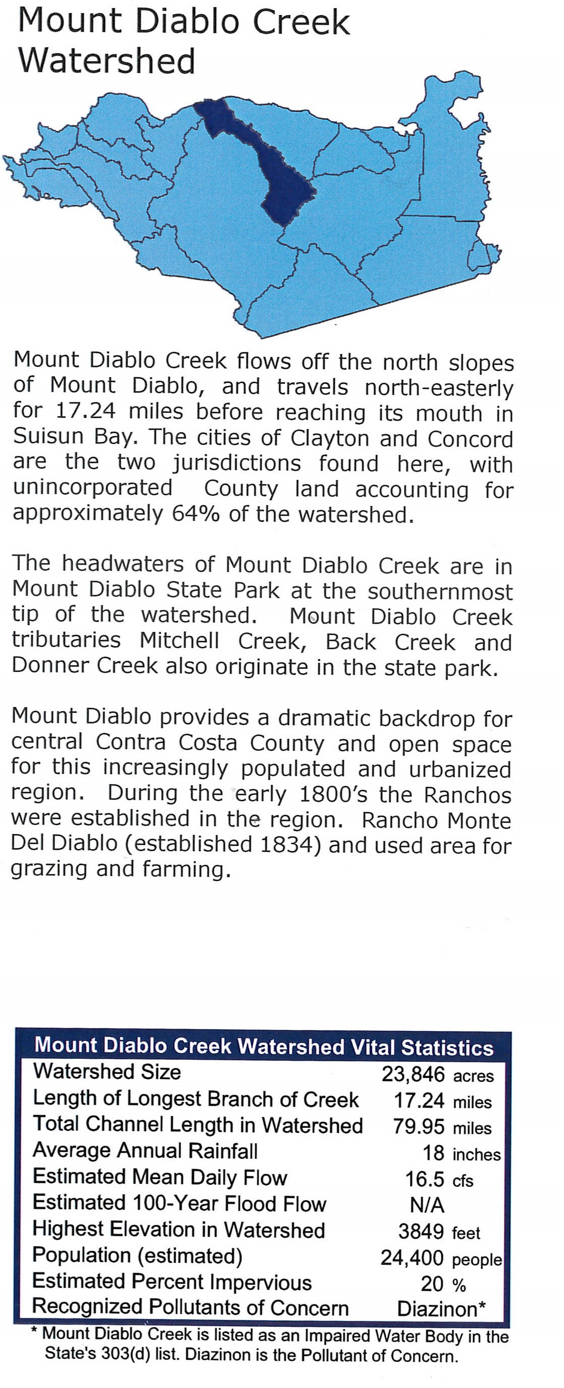
With all the water in the creeks, questions arose as to where the water goes. Here is what I found:
Historical creek map
http://explore.museumca.org/creeks/AA-OBEastCoCo.html
http://www.cccleanwater.org/wp-content/uploads/2016/03/Mount-Diablo-Creek-Watershed-cropped.jpg
Wednesday, March 7, 2018
03-07 - Shell Ridge
15 of us enjoyed a warm, sunny day at WCOS Shell Ridge Preserve. We started from the Sutherland Dr trailhead and turned immediately right (east) on the Fossil Hill Tr. We followed the Indian Creek Tr ESE and then walked North to Ginder Gap. There the group split with the larger number walking up to the ridge and the remainder following Corral Springs Tr along the north side of the ridge. We met at the big oak by Indian Valley Elementary School and completed our loop to the cars via Fossil Hill Tr. 3.54 for Ridge top group; 3.25 for the others.
The section of Fossil Hill closest to the entrance is being tended and the plantings "enhanced" with big swaths of seeded in wildflowers...we saw Poppies, Chinese Houses, Popcorn flower, Phacelia, Yarrow, etc. There are hoses and flags marking plants of interest. Well worth a visit if you have a little bit of time as you don't need to walk very far.
https://www.flickr.com/gp/momcat_ksw/T0i0oK
Wednesday, February 28, 2018
2/28 - Valley Vista
It was a big group on this chilly, gray day before a much anticipated rain storm. 16 of us walked from the Valle Vista Staging area along the Kings Canyon trail until it began ascending. Then we retraced our steps and turned left on the Riche Loop (aka Meadow trail). http://www.ebmud.com/files/6914/3284/4664/south.pdf for a map. Many of the walkers knew nothing of the history of the area and were surprised by the evidence of long ago residences.The hike was about 2 1/2 miles. On our return to Moraga, most adjourned to CiCi Cafe for coffee and more fellowship.
So far (2:30) the rain has not made it to our area.
https://www.flickr.com/gp/momcat_ksw/803503
Thursday, February 22, 2018
2-21 Black Diamond
Just six of us today on what started as a cold morning and became a lovely winter day. We went up the stairs by the Greathouse visitors center, up Chaparral Loop to the junction with Manhattan Canyon Tr.; then to the top of the canyon and the junction with the Black Diamond fire road. When the trail began to descend we retraced our steps and had our lunch on the rocks looking down the valley to the Stewartville area. We returned down the fire road to the Rose Hill Cemetery and then on to the cars. Part way down we encountered a large herd of sheep with just two shephers and two dogs to control them (which they did very well). It was excedingly dry! There was evidence of the lack of water in the reduced size of the shooting stars. But we did see some flowers and there were patches of green. About 3.75 miles.
https://www.flickr.com/gp/momcat_ksw/1d058j
Wednesday, February 14, 2018
2-14 Vargas Plateau
A baker's dozen of us took a Valentines Day hike in the newly reopened Vargas Plateau Regional Park in the hills to the east of Fremont. We split into two groups but covered much of the same territory. The larger group had lunch at the viewpoint and the smaller group ate at the rocky point. There were lots of birds! We saw plenty of hawks, but the only ones I could definitely identify were a red tail and a northern harrier. Also meadow larks (another hiker counted 37 in one flock), bluebirds, juncos and the usual crows. Mileage varied from 3-ish to almost 4 miles.
https://www.flickr.com/gp/momcat_ksw/S3Hfx3
Wednesday, February 7, 2018
2/7 - Crocket Hills
There were just 7 of us hiking on this lovely early spring day. We started from the staging area on Crockett Blvd and went up the Edwards Creek Tr to Wood Rat Tr (Dirca and Oso Berry). We went thru the tunnel under Cummings Skyway and walked SE as far as the picnic tables above Big Valley Trail. It was too windy there to enjoy our lunch break, so we back tracked to the pond and ate there, more or less out of the wind. We returned to the tunnel via Soaring Eagle Tr and descended to the parking lot via Crockett Ranch Tr. (Ribes) 5.15 miles
https://www.flickr.com/gp/momcat_ksw/Jd680G
Wednesday, January 31, 2018
1/31 - Morgan Territory
On a day which started with a Super (at perigee), Blue (2nd full moon in the month), Blood (total eclipse) moon, 14 of us hiked a long loop in Morgan Territory Preserve. We all started out Condor, Volvon, and Blue Oak trails. Then 4 went further out Volvon toward Bob Walker Ridge while the rest of us turned back on Volvon to Prairie Falcon Trail. The big group had their lunch on the rocks at the edge of the canyon; the smaller group truned back and met us near the south end of Prairie Falcon. It was a glorious day with bright sky, warm sun and swarms of bees humming in the blooming manzanitas! 4 miles for the shorter loop; about 4.75-5 for the longer hike.
https://www.flickr.com/gp/momcat_ksw/x784J3
Subscribe to:
Posts (Atom)